

Precision GPS Free

Precision GPS Free açıklaması
'Precision GPS Free' uses your device's GPS sensor to measure your location more accurately than is possible with typical GPS apps. Turn your phone or tablet into a precision GPS instrument.
Normally, software on your Android device determines your location from individual GPS readings. This is fine if your are interested in getting your location to within about 10 meters. However, it is possible to do better than this if you average many readings at a particular location.
This app is designed to do just that -- average many readings of a stationary Android device to get a more accurate location; it actually calculates a weighted average, accounting for the accuracy of each reading. The trade-off is time. You will need to wait a least a few minutes to get a high accuracy average location.
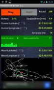
'Precision GPS Free' displays the following information on the main screen:
-'start/stop' button,
-'reset' button,
-battery power remaining as percentage,
-current latitude and longitude,
-round number,
-elapsed time,
-number of GPS satellites in view,
-number of GPS satellites employed in fixing location,
-signal-to-noise ratio of signal from each satellite,
-accuracy of the current readings,
-weighted average (mean) latitude and longitude,
-graph of the current latitude and longitude (white connected points) and the average value (red dot),
-bounding 'scale box' (green) around mean position with a width and a height of 2 meters.
The reset button is inactive while readings are being taken. It can be used after the 'stop' button is pressed. If the measurements are stopped and then started again without pressing the reset button, then only the 'elapsed time' value is reset.
The latitude and longitude values are shown on the graph. North is towards the top and east is toward the right, as in a map. The graph automatically rescales to include the extreme values of longitude and latitude each time it updates the graph (every four seconds). The green scale box is not always square in shape, since the graph latitude scale is not necessarily the same as the graph scale in longitude.
The app times out after 30 seconds if the device cannot get a satellite fix.
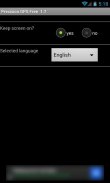
A 'settings' screen provides an option to keep the screen continuously on while the app is running.
Localization language support is provided for French, German, and Spanish.
This app does not save or transmit any personal information, including location or pictures. All the required permissions relate to the GPS operation and the ads.
Applications of 'Precision GPS Free' include navigation, geocaching, prospecting, emergencies, surveying a property, observational astronomy, and archaeology.
A pro version of this app is also available, called 'Precision GPS Pro'. It adds elevation and HDOP, PDOP, VDOP data and options to save the location (and copy to the clipboard), change the interval that readings are taken, display UTM coordinates, display a sky map of the active satellite positions, run in the background, change the format of the coordinates, and send the average coordinates to a mapping app, such as 'Google Maps.' The pro version is also ad-free.
If you have any suggestions for improvements or problem reports, please contact us at ggonzo47@gmail.com.
'Hassas GPS Serbest' tipik GPS uygulamaları ile mümkün olandan daha doğru konumunuzu ölçmek için cihazınızın GPS sensörünü kullanır. Hassas GPS aracı haline telefonunuzu veya tabletinizi çevirin.
Normalde, Android cihazınızda yazılım bireysel GPS okumalarından konumunuzu belirler. Senin yaklaşık 10 metre mesafede konumunuzu almak isteyen varsa bu gayet iyi. Ancak, belirli bir yerde pek çok okumaları ortalama eğer bu daha iyi yapmak mümkün.
Bu uygulama sadece bunu tasarlanmıştır - Daha doğru bir konum elde etmek için sabit bir Android cihazı ortalama birçok okumalar; aslında her okuma doğruluğu için muhasebe, ağırlıklı ortalamasını hesaplar. trade-off zamanı. Bir yüksek hassasiyetli ortalama konumunu almak için en az birkaç dakika beklemeniz gerekir.
'Hassas GPS Serbest' ana ekranda aşağıdaki bilgileri görüntüler:
-'start / durdurma 'tuşu,
-'reset 'butonu
yüzde olarak geri kalan -akü gücü,
-current enlem ve boylam,
-round numarası
-geçen zaman,
, görüntü dahilindeki GPS uydularının-sayısı,
konumu sabitleme kullanılan GPS uyduları -sayısı,
Her bir uydu sinyalinin -Sinyal-gürültü oranı,
Mevcut okumaların -Doğruluk,
-ağırlıklı ortalama (ortalama) enlem ve boylam,
Geçerli enlem ve boylam (beyaz bağlı puan) ve ortalama değer (kırmızı nokta) -graph,
'Ölçek kutu' (yeşil) etrafında ortalama genişliği pozisyonu ve 2 metre yüksekliğe -bounding.
okumalar atılıyor ederken reset düğmesi etkin değildir. 'Dur' düğmesine basıldıktan sonra bu kullanılabilir. Ölçümler durdu ve sonra sıfırlama düğmesine basmadan tekrar başladı, o zaman sadece 'geçen süre' değeri sıfırlanır.
enlem ve boylam değerleri grafik üzerinde gösterilmiştir. Kuzey Yukarıya doğru ve doğu harita gibi, sağa doğru değildir. grafik otomatik olarak boylam uç değerler dahil ve grafik (her dört saniyede bir) güncellemeleri her zaman enlem yeniden ölçeklendirilir. Grafik enlem ölçeği mutlaka boylam grafik ölçeği aynı değildir çünkü yeşil ölçek kutusu her zaman, şekil kare değil.
30 saniye sonra uygulama süreleri cihazın uydu düzeltme elde edemezsiniz.
Bir 'ayarları' ekranı uygulaması çalışırken sürekli açık ekranı korumak için bir seçenek sunar.
Yerelleştirme dil desteği Fransızca, Almanca ve İspanyolca sağlanır.
Bu uygulama konum veya resim dahil olmak üzere herhangi bir kişisel bilgi, kaydetmek veya iletmez. Gerekli tüm izinler GPS operasyonu ve reklamlar ile ilgilidir.
'Hassas GPS Free' Uygulamaları navigasyon, geocaching, zenginleştirilmesi, acil bir özellik ölçme, gözlem astronomi ve arkeoloji sayılabilir.
Bu uygulama yanlısı bir versiyonu 'Pro Hassas GPS' olarak adlandırılan, de mevcuttur. Bu arka planda çalışan yükselme ve HDOP, PDOP, VDOP veri ve konumu kaydetmek (ve panoya kopyalama) seçenekleri, aktif uydu pozisyonları bir gökyüzü haritası görüntüler, ekran UTM koordinatları, okumalar alınır aralığını değiştirmek ekliyor , koordinatların biçimini değiştirmek ve gibi bir eşleme uygulaması, ortalama koordinatlarını göndermek 'Google Maps.' Pro versiyonu da reklam ücretsizdir.
Eğer iyileştirmeler veya sorun raporları için herhangi bir öneriniz varsa, ggonzo47@gmail.com adresinden bize ulaşabilirsiniz.


